The following info have been kindly provided by the VerticalAstico association. All contacts below.
To better understand what a Via Ferrata is I suggest to read this cool article.
The Rings of the Anguane are not only a via Ferrata, but a network of hiking trails and Ferratas, created in San Pietro, a small village located in the upper Astico Valley – Valle dell’Astico (Vicenza).
This work completes the Alpine Park that the upper valley can offer to mountain lovers, both for excursions and rock climbing.
In addition to the numerous paths and mule tracks that connect the valley to the various peaks and the three plateaus, this park has a rock gym in the Torra Valley in S. Pietro Valdastico, with over 47 routes having vertical developments up to around 38m and several routes of rock climbing, with difficulties well beyond the 7th grade UIAA, with vertical developments up to 250 / 300m.
The Rings of the Anguane have the advantage of being easily reachable, they can be traveled throughout the year, their routes have increasing degrees of difficulty starting from hiking up to an Extreme Ferrata and can be configured in function of own climbing capability.
How to get to San Pietro Valdastico
- From the south from the A4 motorway coming from Verona, take the Valdastico A31 motorway to Piovene Rocchette, continue towards Trento along the SP350 provincial road, pass in sequence Cogollo del Cengio, Arsiero, Barcarola, Forni, Sojo until you reach the deadline Frosinone Maso di Valdastico. After crossing the bridge over the Astico river, you arrive at the hamlet of Cerati di San Pietro Valdastico, for a total of approximately 57km.
- From Trento Sud, exit the A22 Autostrada del Brennero motorway, take the SS350 towards Vicenza to Nosellari, continue on the SP350 from Lastebasse to the Maso bridge, for a total of approximately 44 km.
- From Besenello south of Trento, section of the E45 Brenner motorway, take the SS350 for Folgaria, then get off at Carbonare and Nosellari, continue on the SP350 as far as the Maso bridge, for a total of approximately 37km.
- From Asiago on the Piovan road to descend to Pedescala fraction of Valdastico, then for SP84 up to S. Pietro Valdastico, or from the Piovan road west of Castelletto, take the dirt road that connects to San Pietro, for a total of approximately 20Km.
Parking in S. Pietro Valdastico
Soccer field in Cerati, Pro Loco not far from Maso Stefani, Checca, South Municipality, North Municipality, Post and under the Church.
San Pietro Valdastico is located at a north latitude of 45° 53′.12.12 “, east longitude of 11° 21 ‘41.72”, and altitude of about 420 m above sea level. The inhabited area is dominated by a large overhanging wall called Sojo (rock) of Mezzogiorno, that because it is illuminated by sunlight on the 12 o’clock a.m.
The Anguane Rings were created on this wall, also using old and historical private paths. The part of the Sojo, affected by all the equipped routes of the Ferrata, involving also the three rocky sharks connected to the south, called Gioe or Joe, which descend towards the town, ending with the wall having at its top a Votive Chapel, has a vertical development of about 400m and horizontal of about 800/1000 m.
The Map
The following Map illustrates the routes of the main paths marked “S”, of the Ferrate marked “F” and it is also highlighting the shortness of approach to the Via Ferrate.
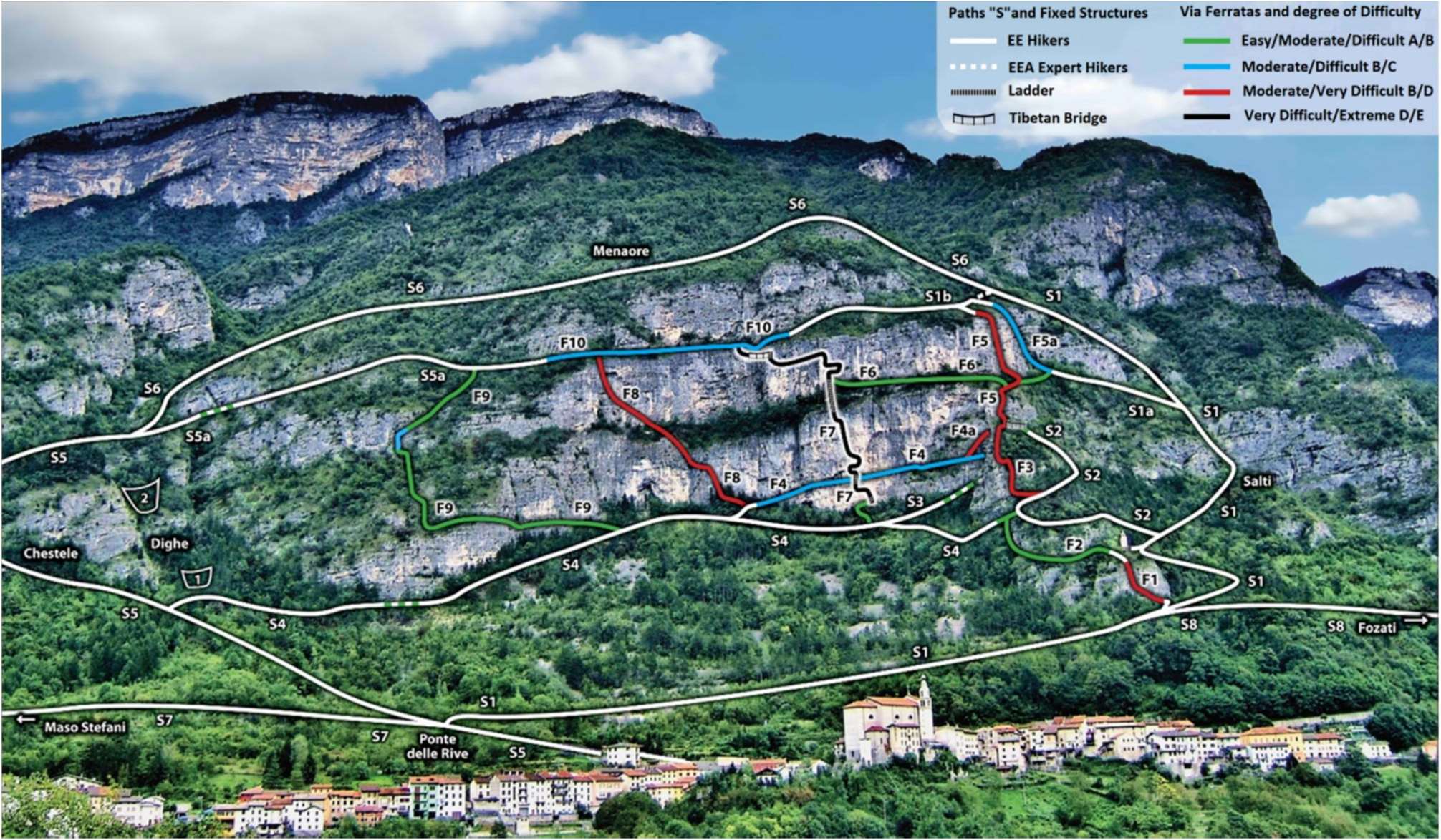
Map of the various paths of the “Anguane Rings” Via Ferrata Park
Difficulty of the routes of the Anguane Rings
Path’s “S”
All paths can be walked on a hiking level, but better to have an adequate physical preparation and lack of dizziness, in particular on the step climb part of S1 called the Salti, S3, S4 and S5a. It is necessary also to have an appropriate mountain equipment like Tracking and Ferrata shoes, Backpack and optional. A lanyard with some carabiner could help along S3, S4, S5a. These paths are moderately easy, but to walk with caution in the equipped sections that are highlighted with a green hatch, it could be advisable to hook safely to the installed steel ropes.
Ferrata “F”
- Marking in Green from Easy to Moderate Difficult;
- Marking in Blue from Moderately Difficult to Difficult;
- Marking in Red from Moderately Very Difficult to Very Difficult;
- Marking in Black from Very Difficult to Extreme.
Details of each Ferrata
F1: climbs vertically the wall of the Prima Joa and leads to the Votive Chapel on its top. The attack starts from Path S1, the equipped route has a development of ropes of about 50m, it is short but vertical and difficult, so it should not be underestimated.
F2: starting from Prima Joa, it climbs to the top of Second Joa at its left up to the base of the corner of the Third Joa. This is the last pyramid, where the
F3 via ferrata develops. The attack is a few meters after the Votive Chapel and the route develops on the Northwest side to the left of the Jo. It has a rope length of about 160m, it is a fully equipped path, Moderately Easy, but with some difficulties at the end when linking with S4. F3: climbs the edge of the Third Joa and its attack begins a few meters from the S4 tract. The route has a length of about 120m of ropes, has some difficult stretches and reaches the top of the pyramid, a few meters from the junction with the Tibetan bridge of the Anguane.
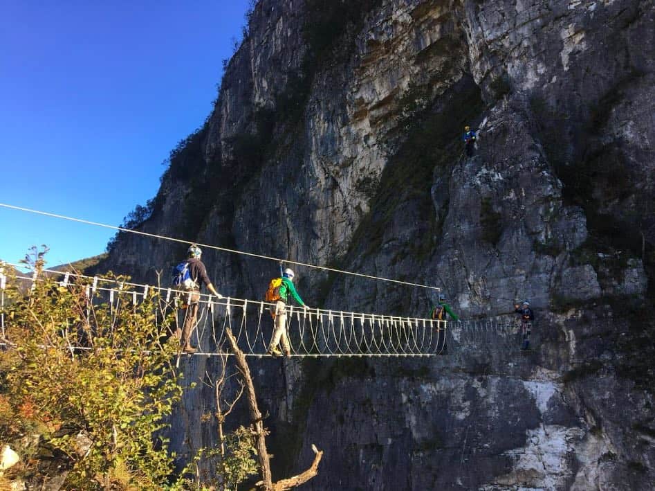
Tibetan Bridge of the Anguane: connects the top of the Terza Joa with the South Face of the Sojo di Mezzogiorno. It has a length of about 21 meters and an average vertical drop of about 40 / 50m. The bridge is assembled with four ropes, one for the sliding of the safety carabiners, two as handrails and one for the support of the feet. Every 35cm, sleepers are connected between the handrail ropes and the foot support rope. Crossing the Ponte delle Anguane requires no dizziness, a good balance and is moderately difficult.
F4: runs along the entire natural ledge that affects part of the wall of the Sojo di Mezzogiorno, which has always been called, Scafa delle Anguane. The attack of the via ferrata starts from the saddle of the Terza Joa, just below the summit, has a development of ropes of about 240m and connects to the north with the S4 path and the F8 ferrata. The path on the ledge is very beautiful and is moderately difficult.
F4a: connects the exit of the Ponte delle Anguane on the Sojo di Mezzogiorno with the Ferrata F4. The development of the ropes is about 50m. It is a path with some Difficult / Very difficult stretches even if well equipped.
F5: climbs the South Wall of the Sojo di Mezzogiorno, the attack is at the end of the Ponte delle Anguane and rises up the Vertical South wall of the Sojo di Mezzogiorno. The route is made up of two rocky walls separated vertically by a bushy and wooded belt, which horizontally crosses the Sojo di Mezzogiorno. This ledge is called Prima Nora. The total length of the ropes is about 150m, the path is at times vertical and very difficult, it has an escape route in F6 in South direction, which connects with the S1a path.
F6: it is an equipped escape route for the two Ferrata F5 and F7, but also linking the Ferrata F5a. The development of the ropes is about 180m and connects to F6 at the end of the large Prima Nora ledge. The difficulty of the route is to be considered from Easy to Moderately Difficult.
F7: climbs the Central Wall of the Sojo di Mezzogiorno, with “Extreme” difficulties for a via ferrata. It should only involve people who are physically well prepared but also having rock climbing knowledge. The walls involved are all vertical and overhanging in several sections. The equipped path excluding the steel ropes, is not full of artificial supports and handles, but it is mainly based on natural supports and handholds. To do it, it needs good resistance and strength of arms. The attack starts from the S4 path in the central base of the wall and the development of the ropes is about 330m. In addition to the ropes, the route is also composed by:
- A dangling chain ladder with 3 steps, a difficult initial impact to advise those who decide to tackle the route;
- A ladder of ropes and rungs in stainless steel of about 7m, which climbs over the Anguane ledge with an inclination of 60° / 70°; The Rings of Anguane – Anelli delle Anguane 4
- A long ladder of ropes of about 40m with rungs in stainless steel, which climbs over the bushy Prima Nora in two sequences, with inclinations of 50° and 60°. The staircase ends a few meters beyond the base of the last vertical section of the Central Wall and connects to the via ferrata escape F6.
- Two walkways each equipped with a footrest rope of few meters, for crossing two small dihedrals. • A ladder of ropes and rungs in stainless steel of about 8m, which vertically connects a Tibetan bridge called Ponte dei Salvanei (in Venetian language) or Salvan (in Ladin language).
- Ponte dei Salvanei formed by 12m of steel ropes (one for Scrolling the safety carabiners, two Handrails and one Footrest), with 6 stainless steel rod sleepers, between the Handrails and the Footrest. The vertical fall up down to the Prima Nora is over 100m.
The F7 Ferrata joins the F10 Ferrata and doing it, must be considered its extreme difficulties. It must be remarked that it must be tackled only uphill.
F8: the path climbs transversely along the north face of the Sojo di Mezzogiorno. The attack is at the end of the Ferrata F4 of the Scafa delle Anguane and the development of the ropes is about 250m; it connects to the top of the F10. The path has several vertical sections and some overhangs. The route, although well equipped, is to be considered very difficult and has no intermediate escape routes. A walkway of a few meters facilitates the overcoming between a pinnacle and the main wall about 70 meters from the base.
F9: connects the base path S4 in the north with the path S5a on the Second Nora and the development of ropes is about 330m. The route is almost entirely equipped, it takes place along very steep and insidious bushy / wooded sections along some rocky ledges. The route is to be considered Easy / Moderately Difficult.
F10: it takes place horizontally along the large northern traverse of the Second Nora, between Paths S1b and S5a. The development of ropes is about 210m. It is very exposed in particular on the final stretch to the north, it requires the absence of dizziness and good balance.
Mandatory equipment to use going on in a via Ferrata
- Shoes for via Ferrata and possibly also spare rock shoes for Ferrata F7;
- Helmet according to European Norm EN 12492.
- Harness according to European Standard EN 121277;
- Heatsink with slings and carabiners according to European Standard EN 959.
Note: on F7 it is also advisable to have one or more Ribbon Rings with Carabiners, to facilitate stops on the wall;
- Gloves for via Ferrata.
- Clothes for Mountain climbing.
The Anelli network allow to combine many routes that could be configured in base on own climbing capability. The Anelli are indicated as Rings of the Anguane, because a local legend indicated this place, as the home of some mysterious and beautiful Nymphs of water. They were very popular on the Alps and Prealps, in particular on the eastern Italian side, also accompanied by the Salvanei or Salvan, characteristic spiteful goblins of the woods on the three Venetian Mountain areas.
Find here (file .pdf) the detailed description of the main loop paths.
Contacts
- VerticalAstico association (managing the Anguane Via Ferrata park)
www.verticalastico.com
[email protected] - VerticalPromotion store: phone#: +39 3205649687.
- Diego Dellai is a “local”, certificated and available, Alpine Guide; phone#: +39 3490597365.